|
Sublette County Historical Points of Interest
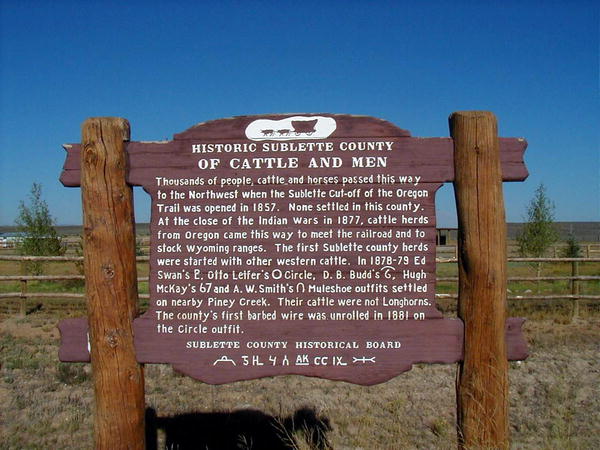
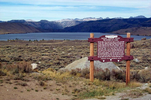
1. 1936 GREEN RIVER RENDEZVOUS The Rendezvous had a broad meaning with the early trappers; not only was it a place to which they carried their furs and exchanged them for all sorts of commodities, such as clothing, saddles, bridles, tabacco, whiskey, bright dyes for coloring the trappings of their horses - but it was a place to meet traders who might wish to engage their services for the coming year. It was indeed a place noted for business, pleasure, mirth, gambling and brawls, and the motley collection was not without interest even to the early missionaries. Along about 1835, religious teachers became a regular feature at the Rendezvous. Rev. Samuel Parker made a number of religious talks to white men and Indians at the Green River in 1835. Father De Smet made a number of his winning and pleasant talks in 1840 at this same place. The Green River Rendezvous are commemorated the second Sunday in July each year at the Museum of The Mountain Man in Pinedale. A large interpretive historical site marker was erected by the Sublette County Historical Society in July 1955 on the Rendezvous grounds near Daniel. It was designed by Jim Harrower and Myra Cooley prepared the lettering. Mrs. Jean Roth cut the stencils and arranged the lettering. The legend on the sign reads: "A market place of the fur trade, from the Mississippi to the Pacific, from Canada to Mexico, where trappers, traders and Indians came to barter for the first great resource of the West. Six Rendezvous were held here, gathering not only furs but information of geographical importance to weld the final link in exploration of the new world. It is a tribute to the brave men, both red and white, who blazed the trails for culture and progress, and to the lowly beaver who gave it impetus" On highways 187 & 189 near the Hoback Rim, a historical sign marking the spot reads: "On this site, Oct. 18, 1811, sixty-one Astorians of the American Fur Company, the squaw of Pierre Dorian and her two children with one hundred and eighteen horses camped for 5 days. They were on their way to the Pacific Ocean from Montreal via St. Louis. Here they met, traded and pow-wowwed with the snake Indians, killed buffalo and cured meat. Continuing their journey they crossed the divide one mile north of here on to the waters of the Columbia River. These were the first white men in what is now Sublette County." The marker was erected by the Historical Society of Sublette County with funds provided by the Sublette County Museum Board, in May 1960. Jim Harrower prepared the legend and checked the site for location. A marker west of highway 189 between Daniel and Big Piney, near the Big Piney Cut-off reads: "Thousands of people, cattle and horses passed this way to the Northwest when the Sublette Cut-off of the Oregon Trail was opened in 1857. None settled in this county. At the close of the Indian Wars in 1877, cattle herds from Oregon came this way to meet the railroad and to stock Wyoming ranges. The first Sublette County herds were started with other western cattle. In 1878-79, Ed Swan's, Otto Leifer's (Circle), D. B. Budd's, Hugh McKay's (67) and A. W. Smith's (Muleshoe) outfits settled on nearby Piney Creek. Their cattle were not longhorns. The county's first barbed wire was unrolled in 1881 on the Circle outfit." The marker was erected in June 1960 at the expense of the Sublette County Historical Society. The text was written by Jim Harrower. A marker located on the Summit of the hill on the road to Fremont Lake reads: "On the edge of this magnificent sheet of water, from 1833 to 1844, Captain William Drummond Stewart of Scotland, camped many times with Jim Bridger and other Mountain Men and the Indians. In 1837 his artist, Alfred Jacob Miller, painted the first pictures of this area. On Stewart's last trip in 1844, eight men in a rubber boat, first boat on the lake, honored their leader by christening these waters as Stewart's Lake in a joyous ceremony near the narrows with a jug of whiskey. Years later this glacier-formed lake with its shoreline of twenty-two miles and over six hundred foot depth was named for John C. Fremont, - the map makers knew not it had been named long before." The marker was erected in November 1960 with funds provided by the Sublette County Museum Board. The legend was prepared by Jim Harrower. The source material was provided by Mr. and Mrs. Clyde Porter, in their research of the newspaper accounts of that time, by the correspondent Matt Field a member of the Stewart Party.
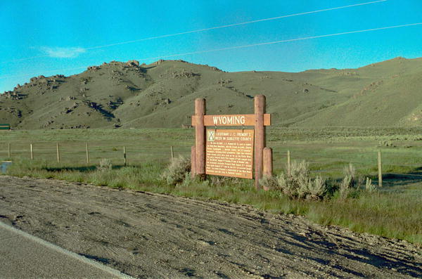
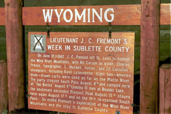
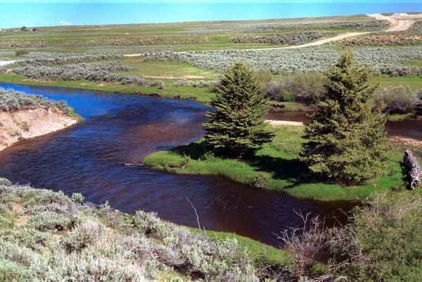
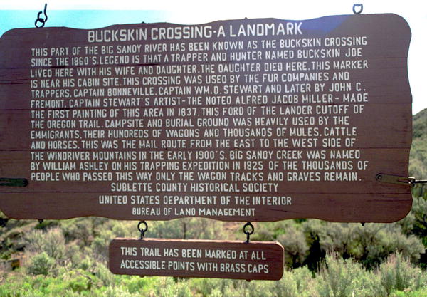
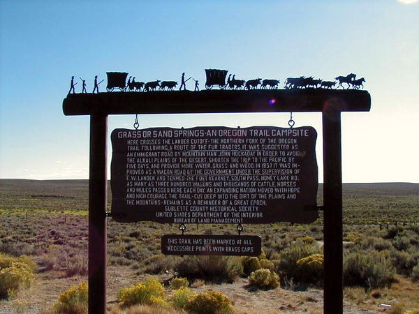
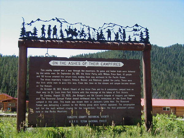
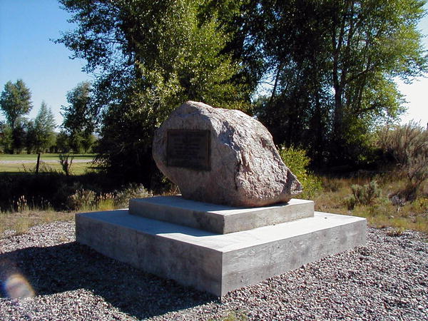
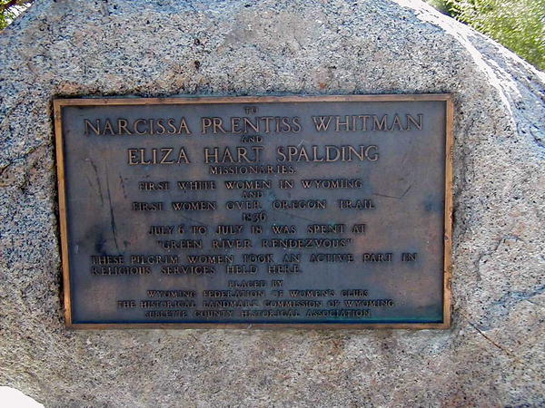
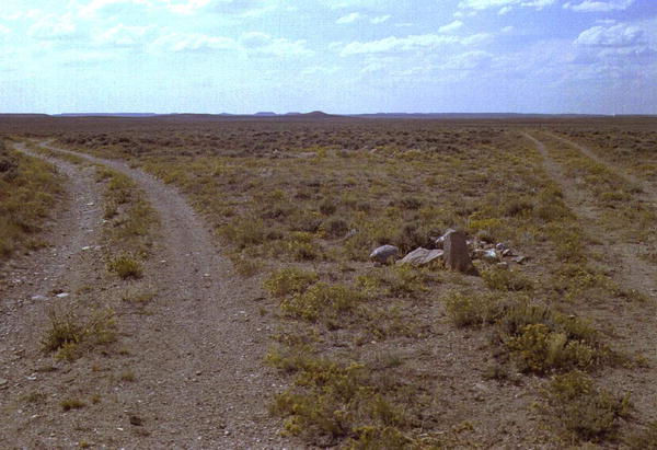
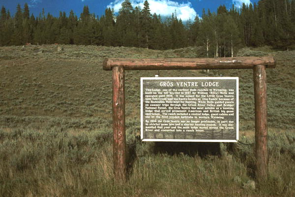
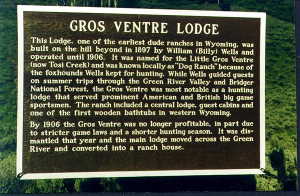
A marker located west of the Pine Creek Bridge in Pinedale, on the North side of the highway reads: "On Oct. 16, 1812, the Astorians Robert Stuart, Ramsay Crooks, Robert McClellan, Joseph Miller, Benjamin Jones, Francis LeClair and Andy Vallee, traveling from Astoria to St. Louis, all their horses having been stolen by Indians, passed this way on foot and forded Pine Creek near here, the first white men known to have seen it. From Stuart's Journal: 'We forded another stream whose banks were adorned with many pines - near which we found an Indian encampment - deserted about a month ago, with immense numbers of buffalo bones strewed everywhere - in the center of camp a great lodge of pines and willows - at the west end three persons lay interred with feet to east and at head of each a large buffalo skull painted black - from lodge were suspended numerous ornaments and moccasins.' Six days later, on Oct. 22, 1812, they made the memorable discovery of the South Pass." The marker was erected in August of 1962 at the expense of the Sublette County Historical Board. The script is by Jim Harrower. A marker on the North side of Horse Creek Road 1 mile west of the intersection with highway 189 reads: "Sisk-ke-dee Agie (Green River) Oregon 1832" "Here in July 1832 Captain Benjamin Bonneville erected a fort, 2 block houses and a stockade as protection from the Blackfoot Indians. He was on leave from the U.S. Army with his trapping and exploring group of 110 men and wagons. These were the first wagons to cross South Pass. The party scattered and trapped for several years, doing valuable exploring as far as California and the Columbia. In the party famed Joe Meeks, Joe Walker and many Delaware Indians. The fort, a strategic site, was not used in winter. Bonneville and most of his party returned to Missouri August 22 1835." The marker was made in the Wyoming State Pen and erected in October of 1962. The source for the legend id from the only material known of Fort Bonneville - "Washington Irving's Captain Bonneville." 7. RENDEZVOUS BIRTH OF AN EMPIRE At a location locally known as Trapper's Point, just west of highway 189 between Pinedale and Daniel with turn-off just west of the Cora Road turn off, on a hill over looking the Green River Valley where most Rendezvous were held a marker reads: "The river below is the Green. The mountains to the west are the Wyomings (Bear Rivers). Those to the east, the Wind Rivers. Along the river banks below are the Rendezvous sites of 1833, 1835 (North Fork), 1836, 1837 (Cottonwood), 1839, 1840 and Fort Bonneville. Trappers, traders and Indians from throughout the west here met the trade wagons from the east to barter, trade furs, gamble, drink, frolic, pray and scheme. The Indians, Delaware and Iroquois, brought by the Hudson Bay Company, Snakes, Bannocks, Gros Ventre, Flatheads, Nez Pierce, Crows and Chinooks here made their first contact with the white man. The warring Blackfeet did not participate. The Rocky Mountain Fur Company, Hudson Bay Company, Captain Bonneville, Wyeth and free trappers, controlled the trade. The people of God, Marcus and Narcissa Whitman, Mr. and Mrs. Spalding, Samuel Parker, Father De Smet, Jason Lee and W. H. Gray tempered the hilarity. Jim Bridger, Milton and Bill Sublette, Tom Fitzpatrick, Joe Walker, Joe Meeks, Kit Carson, Batiste Gervais, Bob Jackson, Moses (Black) Harris, Lucien Fontenelle, Etiene Provat, Henry Freab, Andy Dripps, Robert Campbelle, Henry Vandenburg, Sir W. D. Stewart and the artist A. J Miller all were part of this and left their names embedded in the annals of the west. Scattering for the value of a beaver plew and to see what was beyond the horizon, their trails became the highways of an empire at the cost of many a violent death." Ten acres of B.L.M land were acquired by the Sublette County Historical Board for the erection of the marker, which was completed in June of 1964 and financed by the Board. Floyd Schneider did the rock work, Charles Coppock the lettering and Jim Harrower the text. A marker near silver creek east of Boulder reads: "On June 10, 1842, J.C. Fremont left St. Louis to explore the Wind River Mountains, with Kit Carson as guide, Charles Preuss, topographer, L. Maxwell, hunter and 20 Canadian Voyageurs, including Basil LaJeunesse. Eight two-wheeled, mule drawn carts were used as far as the Platte River. The party crossed South Pass August 8 and camped here at "Two Buttes" August 9. Leaving 10 men at Boulder Lake, the lieutenant ascended Fremont Peak August 15, stayed her again August 17, and on the 19th re-crossed South Pass. So ended Fremont's exploration of the Wind River Mountains and his stay in Sublette County." The marker was made at the Wyoming State Penitentiary and erected in December 1963. Jim Harrower found the source for the material in the legend in the diary of Fremont's cartographer Charles Preuss. He was a German, and the diary was found after World War II. 9. SEEDS-KEE-DEE-AGIE, SPANISH RIVER, RIO VERDE, GREEN RIVER A large marker located on the east side of highway 189, between Labarge and Kemmerer, across from Holden Hill reads: "To the Shoshone Indian, this river was the Seeds-Kee-Dee Agie (Prairie Chicken River). On Sept. 16 1811, the Astorians near it's headwaters termed it the Spanish River. To the Spaniards, far to the south, it was the Rio Verde (Green River). Jedediah Smith and his Mountain Men, making the first westward crossing of the south Pass by white men, camped near here Mar 19, 1824 on the Seeds-Kee-Dee. They trapped the river and its forks which were named for them: LaBarge, Ham's, Black's, Smith's, Henry's, etc. These waters were considered as the greatest beaver waters ever known. The upper reaches became the center of the fur trade and the Rendezvous. In 1841 the fur trade ceased, but the trappers had blazed the trails for the emigrants. For forty-nine years over the Oregon and California trails, thousands of emigrants going west, crossed these waters nearby. The many that drowned and died were buried along the river banks. The Mountain Men guided, manned the ferries and traded with the emigrants. Graves, marked and unmarked, names cut in the rocks and wagon trails worn deep remain with the legend and lore of a great river of the West - The Green." The marker was made and erected with the help of Lincoln County Bureau of Land Management and the Sublette County Historical Society, and was completed in the fall of 1964. The name and script are by Jim Harrower. A marker at Buckskin Crossing of Big Sandy Creek on the east side of the road reads: "This part of the Big Sandy River has been known as the Buckskin Crossing since 1860's. Legend is that a trapper and hunter named Buckskin Joe lived here with his wife and daughter. The daughter died here. This marker is near the cabin site. This crossing was used by the fur companies and trappers, Captain Bonneville, Captian W.D. Stewart and later by John C. Fremont. Captain Stewart's artist - the noted Alfred Jacob Miller - made the first painting of the area in 1837. This ford of the Lander Cut-off of the Oregon Trail, campsite and burial ground was heavily used by the emigrants, their hundreds of wagons and thousands of mules, cattle and horses. This was the mail route from the east to the west side of the Wind River Mountains in the early 1900's. Big Sandy Creek was named by William Ashley on his trapping expedition in 1825. Of the thousands of people who passed this way only the wagon tracks and graves remain. This trail has been marked at all accessible points with brass caps." The marker was erected in June of 1965 with the assistance of the U. S. Dept. of the Interior, and Bureau of Land Management. 11. JAMES BRIDGER - TRAPPER 1844 Names Hill, located on the west side of Highway 189 about 5 miles south of LaBarge, is a very important location, being on the west side of the Green River where thousands of people made a crossing and camped before going on to Immigrant Springs and on down into Utah. Hundreds of names had been carved in the rocks: many of them now have crumbled away. The most famous is James Bridger. To protect it a fences has been placed around it and a marker placed next to it which reads: "He little knew that when he cut his name, or had it cut, in this stone, that it would be engraved in the annals of the West deeper than that of any other man. As one of the world's outstanding explorers he guided emigrants, railroads and army in the expansion of the nation" The sign was made by the Sublette County Historical Society; and with the help of the Lincoln County Board of Commissioners and the Highway Department, put the fence around the area. The First National Bank of Kemmerer put a marker right by the road that lead over the bank between the cliffs. This road can still be followed and is well marked, but there are washes in places making it hard to travel except by 4 wheel drive vehicles. Located on the Pinedale-Rock Springs Road (Highway 187) approximately half way to Farson, a marker reads: "Here crosses the Lander Cut-off - the northern fork of the Oregon Trail, following a route of the fur traders. It was suggested as an emigrant road by Mountain Man John Hockaday in order to avoid alkali plains of the desert, shorten the trip to the Pacific by five days and provide more water, grass and wood. In 1857 it was improved as a wagon road by the Government under the supervision of F.W. Lander and termed the Fort Kearney-South Pass-Honey Lake Road. As many as three hundred wagons and thousands of cattle, horses and mules passed here each day. An expanding nation moved with hope and high courage. The trail, cut deep into the dirt of the plains and the mountains, remains as a reminder of a great epoch." The sign was erected in Late June of 1965 with the help of the B.L.M., Dept. of Interior, and Sublette County Historical Society. 13. OREGON TRAIL - LANDER CUT-OFF (SOUTH PASS AREA) A marker at South Pass reads: "This is an old Indian trail used by the Indians and the trappers of the fur period. A short-cut to the Snake River country, it was proposed as an emigrant road by the Mountain Man John Hockaday in 1854. No emigrant trails crossed the mountains north of here. It was improved as a wagon road for the Government by F.W. Lander in 1859 to avoid dry wastes of the road to the south and provide more water, wood and forage. Here it commenced, the crossing of the south end of the Wind River Mountains and the Continental Divide and on to the Pacific northwest. Thirteen thousand people and thousands of domestic animals passed this way in 1859 and thirty years thereafter was used as heavily, setting the destiny of an empire. These wagon tracks and lonely graves, a great landmark of history have been recognized for preservation by: U.S. Department of the Interior - Bureau of Land Management and Sublette County Historical Society. This trail has been marked at all accessible points with brass caps." A marker on highway 189-191 just south of the Hoback Rim reads: "This nearby canyon was a way through the mountains. Its game and Indian trails were followed by the white men. On Sept. 26 1811, the Astor party with William Price Hunt, 61 people and 118 horses entered the canyon here, making their way westward to the Pacific Ocean." "The three legendary trappers, Hoback Reznor and Robinson, guided the party. These were the first white men to pass this way. From this time on the stream and canyon became known as The Hoback." "On Oct. 10 1812, Robert Stuart of the Astor firm and his 6 companions camped here on their way to St. Louis from Fort Astoria with the message of the failure of Fort Astoria." "On Sunday, Aug. 23 1835, Jim Bridger and Kit Carson's brigade of trappers and Indians and the Reverend Samuel Parker, bound northward from the Rendezvous on the Green River, camped in this area. This basin was known then as Jackson's Little Hole. The Reverend Parker was delivering a sermon to the motley group when buffalo appeared. The congregation left for the hunt without staying for the benediction. This was the first Protestant services held in the Rocky Mountains." The marker was erected by the Sublette County Historical Society and the U.S. Forest Service - Teton National Forest. A marker about two miles south of Daniel on Highway 189 reads: "Rev. Pierre De Smet (1801-1873) was born in Belgium but came to America in 1821, joined the Jesuit Society and begun his work with the Indians. In his work he established 16 treaties, crossed the ocean 19 times and travelled 180,000 miles on his errends of charity for the Indians who knew him as 'The Sincerest Friend.' "On July 5, 1840, in the presence of 2000 Indians, trappers, and traders he offered the first Holly Mass in what is now Wyoming on an alter of native stone decorated with wild flowers. In Father De Smet's own words, 'It was a spectacle truly moving to the heart of a missionary that this immense family, composed of so many tribes should prostrate themselves in equal humility before the Divine Host.' "The monument at the site was erected in 1925 and a commemorative mass is offered there annually in July. On July 4, 1940, the 100th anniversary of the first mass, a Pontifical High Mass was offered by the Most Rev. Bishop McGovern assisted by more than 30 priest and attended by about 2000 people." A little chapel was erected by the Catholic Church on the knoll above the Green River where the first Catholic Mass was held by Father De Smet, just east of the Road Marker on highway 189 south of Daniel. Each year on the first Sunday in July services are held there. A marker on the east side of highway 189 just north of Daniel reads: "To Narcissa Whitman and Eliza Hart Spalding Missionaries. First white women in Wyoming and first women over the Oregon Trail 1836. July 6 to July 16 was spent at Green River Rendezvous. These Pilgrim Women took an active part in religious services held here. Placed by Wyoming Federation of Women's Clubs, The Historical Landmark Commission of Wyoming, Sublette County Historical Society." The marker was erected to commemorate the 100th year after the two white women had made their 10 day stay in the area. Five acres were bought by the Sublette County Historical Society when it was first organized in 1936 that are in the middle of the area where 6 of the early Rendezvous were held. The Society was organized and the first of the recent Rendezvous enacted on these acres, in honor of Eliza Spalding and Narcissa Whitman. This marker is on the main highway between Farson and Lander, in the very southeastern corner of Sublette County. Most of the people heading west camped at Pacific Springs North of the Oregon Buttes. After traveling in groups for several more miles west some decided they would rather goo to the gold fields in California, or to the area the Mormons were settling in Utah, and it was at this spot that the groups parted, many still determined to go on to Oregon. These old trails can still be seen and have been marked. As stated on the sign the first known persons to pass over South Pass were Robert Stewart and friend as they made their way east to take messages to John Astor of the Pacific Fur Company, in the fall of 1812. Twelve years later the Ashley-Henry men made their way back to the beaver trapping areas led by Jedediah Smith and Tom Fitzpatrick. By 1836 many groups were using that way west, and in that year the missionaries and wives were headed for Oregon. Eliza Spalding and Narcissa Whitman were the first known white women to go over the route. The peak year for travel was 1852 when it is estimated that over 40,000 persons passed this way. 19. GRAVE OF CHARLOTTE DANSIE - 1862 A tombstone on the road from Farson to Lander reads: "But should we die before our journey is through, all is well, all is well." In loving memory of Charlotte R., daughter of Wm. and Susan Rutland born in Suffolk England. Died in child birth with infant son Joeseph at Pacific Springs Wyo. Sept. 21, 1862, while crossing the plains to Utah. In Ansel P Harmon Co. leaving husband and five children. Caroline Moyers buried in the same grave. Died Sept. 21 1862 of Bilious fever age 25 years. Grave located July 3, 1939 by Joseph H. and Leroy Dansie. Erected in 1939. Emigrant Springs was a well known area for the parties to pass through to Utah and California. It is an isolated spot and hard to locate for those who do not know the correct road to it, but it was a lush meadow with a large spring of cold water, where the women could wash, people bathe, horses get rested up, etc. It is hard to say how many people may have been buried there. The two known graves are being washed out. A rock slab was put up by Cap Nickerson of Lander in 1915. It said Oregon Trail 1843. This stone has been removed by some thoughtless person. The spring is enclosed by rocky bluffs on which hundreds of names are carved, many of which are hardly legible now. Emigrant Springs is on the west side of the highway between Fontenelle and Slate Creeks. An Oregon Trial marker is seldom seen as it is on the Trail between the Sweetwater crossing and Pacific Springs. It is not known how many years ago it was put up or by whom. In several places the Oregon Trail and Lander Cut-off have markers that have been chiseled in rocks by people passing. In later years the old trail was marked by cement posts with bronze plaques embedded in the top of each one. The marking took several summers and was carried out by the Sublette County Historical Society, the U.S. Dept. of the Interior and Bureau of Land Management. Many of the bronze markers have been pried off the posts by thoughtless people, so seldom does anyone get to see one with the plaque still on. 22. BIRTH OF A BABY ON JULY 3RD 1864 This was a rare find. Many grave markers have been found along the Oregon Trail but this is the only known one marking a birth. Exactly one hundred years after the date on the marker a group of interested people gathered to picnic and to set the stone in concrete as a permanent marker. It was found near this spot, on the Dan Budd ranch, not far from Big Piney by a young woman. The stone had "Monlen Hefflem born here July 3rd 64" on it with the date again chiseled out on the back. On a bench east of Green River, on the way to Green River Lakes approximately 30 miles north of Cora, Wyoming a marker reads: "The Gros Ventre Lodge, believed to be the first full time dude ranch in Wyoming was built on the hill beyond in 1897 by William (Billy) Wells and operated until 1908. It was named for the Gros Ventre (now Tosi Creek) and was locally called the 'Dog Camp' because a pack of hounds was kept for hunting. Improvements included a central lodge, guest cabins, and service buildings. Big game hunting was the chief attraction and drew prominent American and European sportsmen for extended vacations. A.B. Wallihan, early noted wildlife photographer made many of his outstanding pictures while staying here. A Postoffice, Wells, Wyoming was established in 1899 and continued during the years the ranch operated. 24. THE OLDEST DATE IN SUBLETTE COUNTY The oldest carving date found in Sublette County is located on the Ferris Ranch near Dell Creek, in the Hoback Basin. Don Ferris found this on a rock covered with shrubs, near his home, where he had lived since about 1919. He found it in 1961. the carving is M A. 1791. It could be an M P. The A or P is indistinct. In Nov. 1966 Jim Harrower and Bill Isaacs checked it out and made a photo. There was about eighteen inches of snow on the ground. The lettering is very old as hard lichens have grown in the indentations. |