|
Sublette Examiner Volume 6, Number 47 - February 15, 2007 brought to you online by Pinedale Online RMP released, at last! Residents and visitors to the one-million-acre area of Bureau of Land Management-administered lands centered on Sublette County should take a look at the Pinedale Resource Management Plan environmental impact statement. Only in its draft form right now, once finalized this document will guide all public use of these public lands for years to come. The plan will describe when, how and where you can use public lands in the area.
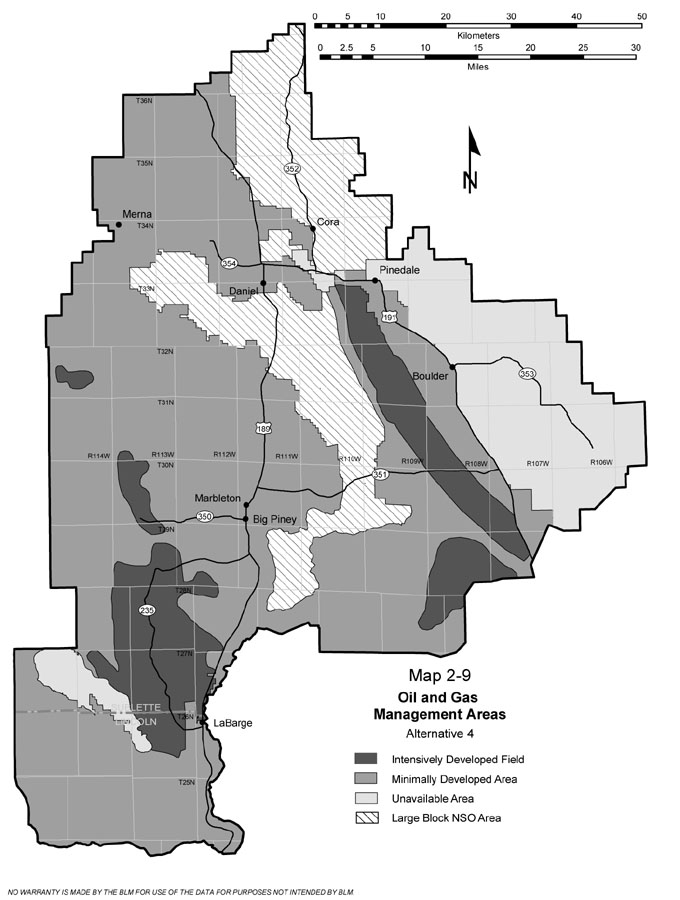
• Alternative One – continuation of existing management as described in the 1988 RMP. • Alternative Two – maximize oil and gas resource production while providing an adequate level of environmental protection for other resources. • Alternative Three –provide the maximum level of environmental protection for all competing resources while allowing for the production of oil and gas resources. • Alterative Four, Preferred Alternative – optimize production of oil and gas resources while providing the appropriate level of environmental protection for all competing resources. A facet of the BLM’s new performance-based planning approach includes dividing the planning area into several management “sections.” Each section would have different goals for managing oil and gas production and conserving wildlife habitat. One section would focus on maximizing the recovery of oil and gas while conserving wildlife habitat as feasible and promoting reclamation of affected habitats. A second section would be available for oil and gas leasing, with strict limits on development at the exploration stage to conserve wildlife habitat and other resources. A third section would be unavailable to oil and gas leasing. Finally, a fourth section would be available for oil and gas leasing, with stipulations prohibiting surface occupancy by oil and gas operators. The proposal: Alternative 4 would make available approximately 1,024,880 acres for oil and gas leasing and development. The 7,136 wells projected under this alternative would potentially extract 19,168 BCF of natural gas and 150 million barrels of oil during the life of the plan. The planning area would be divided into four areas for management of oil and gas leasing and development. Intensively Developed Fields encompassing about 175,750 acres would be managed for intensive oil and gas activities while protecting wildlife habitats to the extent practicable. Minimally Developed Areas (672,470 acres) would be managed for protection of important values during oil and gas exploration, but would provide opportunity for intensive oil and gas activities. Large Block NSO Areas (205,100 acres) would be managed for protection of wildlife habitats through offering oil and gas leases with “no surface occupancy” stipulations. Unavailable Areas (156,900 acres) would be managed for protection of wildlife habitats through indefinitely postponing the availability of lands for oil and gas leasing. About 14,000 acres, including Trapper’s Point, New Fork Potholes, CCC Ponds and the East Fork River Unit, would be withdrawn from locatable mineral entry. The current permitted animal unit months for livestock grazing would be maintained unless monitoring indicates a need for adjustment. OHV use in the Desert General Use area would be limited to existing roads and trails. Special Management Areas The Rock Creek and Beaver Creek areas of critical environmental concern would be retained, while new ACECs would be designated in the Trapper’s Point and New Fork Potholes areas. Other special management areas would be designated and would include the Miller Mountain, Ross Butte, and Wind River Front areas, encompassing 303,350 acres. Four river units would be managed as suitable for inclusion in the Wild and Scenic River System: East Fork, Scab Creek, Silver Creek, and the upper Green River. Socio-Economics According to the EIS, under the preferred alternative, the pace of gas development and production would be expected to be very similar to the current management situation, with a 181 percent increase in the number of wells between 2006 and 2020. Over the 20-year study period, employment would be expected to average more than 10,000 direct, indirect, and induced jobs per year, which would be slightly less than under current management. Slight declines in employment would be expected as slightly less oil and gas development would be permitted, while increases in recreational activities would be expected to have a small impact on employment. Regional incomes under the preferred alternative would be expected to be slightly higher in the study area compared to now, rising to exceed $6.9 billion. Quality of Life Overall, BLM management under the preferred alternative would cause dissatisfaction among individuals and groups that were displaced by development activities, the EIS predicts. Some stakeholder groups, such as conservationists, nonmotorized recreational groups, and other wildlife protection groups, would likely perceive a decreased quality of life as a result of well drilling and field development. “In some cases, these groups might experience long-term impacts from a loss of open landscapes and solitude as a result of development activities’ use of the planning area,” according to the EIS. “However, others in the community, such as local business interests, long-term residents, and local and state government representatives, might support further development activities, which they might feel increase the economic and cultural diversity of the area and increase the overall standard of living.” See The Archives for past articles. Copyright © 2002-2006 Sublette Examiner All rights reserved. Reproduction by any means must have permission of the Publisher. Sublette Examiner, PO Box 1539, Pinedale, WY 82941 Phone 307-367-3203 examiner@wyoming.com |